
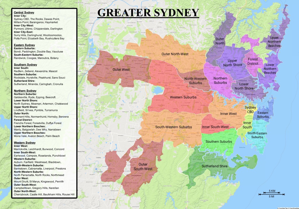
Sydney’s South Eastern Suburbs are a prominent, vital and yet often overlooked part of Sydney. Sydney’s South Eastern Suburbs are best described as the southern part of Eastern Sydney which are all the suburbs that lie south-east of the Sydney Central Business District. The most prominent district within Sydney’s South Eastern Suburbs is Randwick City Council which begins with all of the suburbs south of The Centennial Parklands starting at Kensington, Randwick and Clovelly then continuing down as far as La Perouse on Botany Bay. Postcodes of Sydney’s South Eastern Suburbs start at 2031 and continue to 2036. The UNSW although being in the suburb of Kensington has the postcode 2052 and Centennial Park which is also part of Randwick City Council has the postcode 2021.
The western boundary for Sydney’s South Eastern Suburbs falls on The Eastern Distributor, Southern Cross Drive and Mill Stream which means there’s a missing portion of this region not covered under Randwick City Council but under Bayside Council with the two mostly being separated by Bunnerong Road. These suburbs include Botany, Banksmeadow, Pagewood, Daceyville, Hillsdale, Eastgardens and the eastern half of Eastlakes. Sydney’s South Eastern Suburbs within Bayside Council were once governed by the former ‘City of Botany Bay’. Most postcodes remain synonymous with that of Randwick City Council with the addition of 2018 and 2019. Sydney’s South Eastern Suburbs roughly correspond with The Federal Division of ‘Kingsford Smith’.
History

With The Municipalities Act of 1858, Randwick Council was established on February 23rd, 1859 making it the first suburban and the second oldest municipality in the Greater Sydney area, City of Sydney being the first, established on July 20th, 1842. The municipalities of Waverley, Glebe, Redfern, Woollahra, Paddington, Waterloo, Hunters Hill, Marrickville, Parramatta and Newtown came shortly after Randwick all establishing themselves within the following few years, most of which have been amalgamated since. Randwick Council started off much smaller than it is today until residential development and transport expanded as far south as La Perouse in the 1900s with most of the area originally being swamps.
The portion of Sydney’s South Eastern Suburbs within Bayside Council were once governed by the Borough of Botany which was established March 29th, 1888 at the same time as the separate neighbouring Borough of North Botany (Mascot). Both boroughs were primarily industrial areas at the time and as development expanded, in 1906 both boroughs were proclaimed municipalities. In 1911, The Municipality of North Botany changed its name to The Municipality of Mascot in order to differentiate themselves from their southern neighbour. In 1949 The Municipality of Mascot was dismantled and all suburbs were amalgamated into The Municipality of Botany. In 1996 The Municipality of Botany was declared The City of Botany Bay before being forcibly amalgamated 20 years later with the City of Rockdale to form the current Bayside Council in 2016.
Landmarks
The largest commercial hubs in Sydney’s South Eastern Suburbs are Randwick and Maroubra Junction which provide transport, services, restaurants, residential space, retail space and office space. A popular locality within Sydney’s South Eastern Suburbs is ‘The Spot’ in Randwick which is a destination filled with restaurants and a famous local cinema called ‘The Ritz’. Annually The Spot holds its own festival with outdoor markets and entertainment. Randwick’s central location within Eastern Sydney is to blame for what makes it such a thriving hot spot.
Shopping centres in Sydney’s South Eastern Suburbs include Royal Randwick Shopping Centre, Pacific Square in Maroubra, Southpoint in Hillsdale and Westfield Eastgardens which is Sydney’s largest south-eastern shopping centre. Westfield Eastgardens lies on the site of the former Pagewood bus depot. The centre was completed in 1987 falling within the suburb of Pagewood and partially Hillsdale before becoming the suburb it is today named after the shopping centre itself.
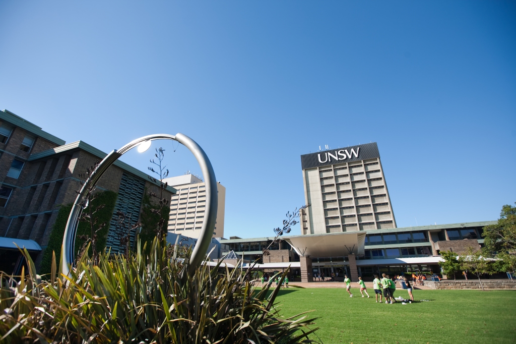
The University of New South Wales (UNSW) is located in the south-eastern suburb of Kensington which is the main university for Eastern Sydney and is one of the top performing universities in Australia. Within the same suburb of Kensington lies the National Institute of Dramatic Arts or ‘NIDA’. Port Botany in the South Eastern Suburbs is New South Wales’ largest container port. Prince of Wales Hospital, located in the south-eastern suburb of Randwick is part of the South Eastern Sydney Local Health District and is the largest hospital in Eastern Sydney.
Transport

The major transportation infrastructure for Sydney’s South Eastern Suburbs is the CBD and South East Light Rail. Completed in 2020 The CBD and South East Light Rail splits at Moore Park with the L2 line terminating at Prince of Wales Hospital in Randwick and the L3 line terminating at The Juniors Leagues Club in Kingsford. The light rail takes residents of both Randwick and Kingsford as well as Kensington to Circular Quay via Moore Park, Surry Hills and George Street in the Sydney CBD.
Major roads connecting Sydney’s South Eastern Suburbs to Sydney CBD are Anzac Parade, The Eastern Distributor, Southern Cross Drive, Bunnerong Road and Alison Road. Other major roads in Sydney’s South Eastern Suburbs include Coogee Bay Road, Clovelly Road, Darley Road, Avoca Street, High Street, Banks Avenue, Arden Street, Malabar Road, Maroubra Road, Beauchamp Road, Rainbow Street and Foreshore Road.
Sporting Culture & Recreation

Sydney’s South Eastern Suburbs are a strong supporter of the NRL South Sydney Rabbitohs. Although based in the Inner Southern Suburb of Redfern, The South Sydney Rabbitohs have leagues clubs called ‘The Juniors’ in Kingsford, Maroubra and Malabar. These clubs provide entertainment and events.
Sydney’s south-eastern racecourse is Royal Randwick Racecourse which is NSW’s largest racetrack and is a popular recreational spot for residents in Eastern Sydney as well as all over Sydney.
Sydney’s South Eastern Suburbs are popular for surfing and beach culture with the popular beaches and bays of Clovelly Beach, Gordon’s Bay, Coogee Beach, Lurline Bay, Maroubra Beach, Malabar Beach, Little Bay Beach, Little Congwong Beach, Congwong Beach, Frenchmans Beach, La Perouse and Yarra Bay Beach in Phillip Bay with Maroubra Beach being Sydney’s largest south-eastern beach.
Golfing is a sport enjoyed by many residents in Sydney’s South Eastern Suburbs with golf courses in Kensington, Eastlakes, Pagewood, Botany, Malabar, Little Bay and La Perouse.
Governance and Politics

Sydney’s South Eastern Suburbs are mostly governed by Randwick City Council with a portion governed by Bayside Council. The Randwick City Council Chambers are in Randwick Town Hall which was completed in 1882.
At the federal government level, the South Eastern Suburbs fall within the Federal Division of Kingsford Smith which extends to Mascot and is named after Sydney Airport. At the state government level Sydney’s South Eastern Suburbs are represented by a few electorates in the lower house. The main electoral district is ‘Marouba’ with a portion of the area also falling within the electoral districts of ‘Coogee’ and ‘Heffron’.
The political allegiances of these electorates and divisions reflect the socio-demographic profile of the region. The Federal Division of Kingsford Smith has been held by the working class ‘Australian Labor Party’ since its establishment in 1949. The same can be said for the electoral districts of ‘Maroubra’ and ‘Heffron’ which have also been held by the Australian Labor Party since each of them was established. The electoral district of ‘Coogee’ is historically a more marginal electorate with parts of it falling within Waverley Council in Sydney’s Eastern Suburbs.
Sydney’s South Eastern Suburbs vs. Sydney’s Eastern Suburbs

Sydney’s Eastern Suburbs can be used as a broad and somewhat loose term which can mean different things to different people. When used in the greater sense Sydney’s Eastern Suburbs can include The South Eastern Suburbs and be synonymous with ‘Eastern Sydney’ however when used in a more conservative and literal sense, Sydney’s Eastern Suburbs are all the suburbs which lie directly east of the Sydney Central Business District within Woollahra Municipal Council and Waverley Council with the two mostly being separated by Old South Head Road. Eastern portions of City of Sydney are also sometimes considered Eastern Suburbs or Inner Eastern Suburbs.
Sydney’s Eastern Suburbs begin with The Centennial Parklands, Paddington to the north, Waverley and Bronte to the east, then continue north as far as Watsons Bay. Postcodes start at 2021 and end in 2030. The Centennial Parklands as a whole are considered part of Sydney’s Eastern Suburbs despite being separated by three councils with Moore Park being City of Sydney, Centennial Park being Randwick City Council and Queens Park being Waverley Council. Sydney’s Eastern Suburbs roughly correspond with The Federal Division of ‘Wentworth’.
The eastern portion of City of Sydney which is sometimes included within Sydney’s Eastern Suburbs are the suburbs of Surry Hills, Darlinghurst, Woolloomooloo, Potts Point, Elizabeth Bay and Rushcutters Bay which includes the famous locality of Kings Cross. These postcodes are 2010 and 2011. These suburbs are often referred to as Sydney’s Inner City Suburbs as well as Sydney’s Inner Eastern Suburbs and are sometimes called ‘East Sydney’. While they are sometimes included as an extension of Sydney’s Eastern Suburbs acting as a conjunction between The Eastern Suburbs and The CBD, from a strict standpoint they are more often than not considered part of Central Sydney and not Eastern Sydney.
The Eastern Suburbs history Follows in the footsteps of the south-eastern council of Randwick which established itself on February 23rd, 1859 as the second oldest municipality in Greater Sydney. Waverley Council taking advantage of the newly established Municipalities Act of 1858 established itself merely months after Randwick on June 16th, 1859 making it the third oldest municipality in Greater Sydney. Woollahra followed Waverley shortly afterwards becoming its own municipality on April 17th, 1860 with Paddington establishing its own municipality at the same time as Woollahra.
The area that once was the Municipality of Paddington has since changed hands several times as the municipality was first amalgamated into City of Sydney in 1948 before most of the area was then separated and amalgamated into Woollahra Municipal Council in 1968 and then once again separated and amalgamated into the then revived South Sydney Council in 1989. Following the amalgamation of South Sydney Council into City of Sydney in 2004 most of what once was The Municipality of Paddington was given to Woollahra Municipal Council with a portion south of Oxford St given to City of Sydney. Vaucluse and Watsons Bay separated themselves from Woollahra in 1895 to form The Municipality of Vaucluse only to be amalgamated back into Woollahra Municipal Council in 1948.
Major commercial hubs within Sydney’s Eastern Suburbs are Bondi Junction and Double Bay with Bondi Junction being the largest commercial hub in Eastern Sydney. Popular localities in Sydney’s Eastern Suburbs include Five Ways in Paddington and Charing Cross in Waverley. Moore Park features the popular recreational destination called ‘The Entertainment Quarter’ formerly known as ‘Fox Studios’. Shopping centres in Sydney’s Eastern Suburbs are Supa Centa in Moore Park, Eastpoint Food Fair at Edgecliff Centre, Eastgate Bondi Junction and Westfield Bondi Junction which is the largest centre in Eastern Sydney, completed in 2003.
Sydney’s Eastern Suburbs has the Eastern Suburbs railway completed in 1979 which stops at Martin Place, Kings Cross, Edgecliff and terminates at Bondi Junction which is part of the T4 Eastern Suburbs & Illawarra Line. Sydney’s Eastern Suburbs’ ferry services go from Circular Quay to Watsons Bay via Rose Bay F2 and Double Bay via Darling Point and Garden Island in Potts Point F7.Sydney’s main seaplane base is The Rose Bay Water Airport. Major roads connecting Sydney’s Eastern Suburbs to Sydney CBD include New South Head Road, Oxford Street and Syd Einfeld Drive. Other major roads in Sydney’s Eastern Suburbs include Old South Head Road, Bondi Road, Hopetoun Avenue, Bronte Road, Military Road, Ocean Street, Bellevue Road, Victoria Road and Birrell Street.
Sydney’s Eastern Suburbs are represented by the NRL Sydney Roosters. The Sydney Roosters have their leagues club called ‘Easts’ in Bondi Junction, their administration in Paddington and play out of The Allianz Stadium in Moore Park. Moore Park also features other sporting grounds such as The Sydney Cricket Ground, The E S Marks Athletics Field and The Moore Park Golf Course.
Popular beaches and bays in Sydney’s Eastern Suburbs include; Double Bay Beach, Redleaf Pool, Lady Martins Beach, Bellamy Beach, Rose Bay Beach, Shark Beach, Parsley Bay Beach, Kutti Beach, Gibsons Beach, Watsons Bay Beach, Camp Cove Beach, Lady Bay Beach, Diamond Bay, Bondi Beach, Tamarama Beach and Bronte Beach with Bondi Beach being the largest beach in Eastern Sydney as well as Sydney’s most famous.
Sydney’s Eastern Suburbs are governed by Woollahra Municipal Council and Waverley Council with smaller pockets governed by City of Sydney. Sydney’s Eastern Suburbs’ electoral district is ‘Vaucluse’ with a portion falling within ‘Coogee’ and ‘Sydney’. Sydney’s Eastern Suburbs federal division is ‘Wentworth’. Both the Electoral District of Vaucluse and the Federal Division of Wentworth have always shown strong Liberal Party support as a result of the region’s socio-demographic profile.
Sydney’s Eastern Suburbs surrounded by Sydney Harbour to the north, the coast to the east, Sydney CBD to the west and The Centennial Parklands in its south is often regarded as one of the oldest and most affluent regions of Sydney.
Sydney’s Inner Southern Suburbs
Another overlooked region which neighbours Eastern Sydney and is often considered difficult to define is Sydney’s Inner Southern Suburbs. Sydney’s Inner Southern Suburbs are best described as the region in between Sydney CBD and Botany Bay within the boundaries of Central Station to the north, The Eastern Distributor, Southern Cross Drive and Mill Stream to the east, The Alexandra Canal and T3 Train Line to the west and Sydney Airport in its south. These are the suburbs of Redfern, Eveleigh, Alexandria, Beaconsfield, Zetland, Waterloo, Rosebery, Mascot and the western portion of Eastlakes.
Sydney’s Inner Southern Suburbs mostly fall within City of Sydney with a small portion within Bayside Council, the two being separated by Gardeners Road. Sydney’s Inner Southern Suburbs are sometimes referred to as ‘South Sydney’ and the suburbs within City of Sydney were once governed by the former ‘South Sydney Council’ while the suburbs within Bayside council were once governed by the former ‘City of Botany Bay’. Sydney’s Inner Southern Suburbs roughly correspond with the electoral district of ‘Heffron’.
Sydney’s Inner Southern postcodes are 2015, 2016, 2017, 2018 and 2020. The missing postcode 2019 belongs to the suburbs of Botany and Banksmeadow which although lie south of Sydney CBD along with the listed suburbs, fall on the other side of Southern Cross Drive and Mill Stream making these two suburbs south-eastern. Eastlakes with the postcode of 2018 is split down the middle by Southern Cross Drive with The Lakes Golf Course and Botany Dams falling east within Sydney’s South Eastern Suburbs while the residential portion of Eastlakes with the shopping centres fall west within Sydney’s Inner Southern Suburbs.
Sydney’s Inner Southern history follows the Municipality Act of 1858 with the first municipality to establish itself in the region being Redfern on August 11th, 1859. The Municipality of Waterloo shortly followed being established on May 16th, 1860 and then The Municipality of Alexandria came several years later on August, 27th 1868. All three councils along with the municipalities of Darlington, Newtown and Erskineville were amalgamated into the South Sydney Council in 1968. The South Sydney Council was then dismantled in 1982 with all suburbs being amalgamated into City of Sydney Council before the revival of a larger South Sydney Council in 1989 that was comprised of all of the original suburbs with the addition of the inner eastern suburbs that had previously always been part of the eastern portion of City of Sydney. The South Sydney Council was dismantled for the second and final time on 2004 with all suburbs once again being amalgamated into City of Sydney.
The portion of Sydney’s Inner South within Bayside Council was once governed by The Borough of North Botany (Mascot) which established itself March 29th, 1888 along with the separate neighbouring Borough of Botany. Both boroughs were declared municipalities in 1906. The Municipality of North Botany then changed their name to The Municipality of Mascot in 1911 for the sake of distinction. In 1949 all suburbs within The Municipality of Mascot were amalgamated into The Municipality of Botany. In 1996 The Municipality of Botany was declared The City of Botany Bay before being forcibly amalgamated with the City of Rockdale in 2016 to form the current Bayside Council.
Major commercial hubs of Sydney’s Inner Southern Suburbs are Mascot and Alexandria with both having a train station, Alexandria’s station being Green Square Station and Mascot also being home to Sydney Kingsford Smith Airport. Green Square is a locality at an intersection where the four suburbs of Alexandria, Beaconsfield, Zetland and Waterloo meet with the train station being named after the locality. While Sydney’s Inner Southern Suburbs don’t have a major Westfield, the region’s indoor shopping centres include East Village in Zetland, Eastlakes Shopping Centre & The Grand, Gardeners Place in Alexandria and The Homemaker Centre in Alexandria. Alexandria is a popular destination for homewares and wholesalers with its main strip being O’Riordan Street.
Sydney’s Inner Southern Railway Line is the Airport Link completed in 2000, part of the T8 Airport & South Line which connects Central Station to Sydney Airport via Green Square Station in Alexandria and Mascot Station. Redfern Station while not part of the T8 Train Line serves is a major train station in Sydney with almost as many platforms as Central Station. The Metro M1 North West and South West Line goes through the Inner South with a metro station in Waterloo. Major roads connecting Sydney’s Inner Southern Suburbs to Sydney CBD are Botany Road, Elizabeth Street and Bourke Street with Botany Road, Gardeners Road and Wentworth Avenue connecting Sydney’s Inner Southern Suburbs to Sydney’s South Eastern Suburbs. Other main roads in Sydney’s Inner Southern Suburbs include McEvoy Street, Euston Road, O’Riordan Street, King Street, Coward Street and Redfern Street.
Like Sydney’s South Eastern Suburbs, Sydney’s Inner Southern Suburbs are represented by The NRL South Sydney Rabbitohs based in Redfern. Their junior leagues clubs (colloquially called ‘The Juniors’) are in the south-eastern suburbs of Kingsford, Maroubra and Malabar and support for the NRL South Sydney Rabbitohs is often extended to southern portions of the Inner West that used to be Marrickville Council.
The Inner South is predominantly governed by City of Sydney with a portion also governed by Bayside Council. At the federal government level the Inner South mostly comes under the Federal Division of Sydney with a portion also under the Federal Division of Kingsford Smith. At the state government level the Inner South is predominantly within the Electoral District of Heffron with a small portion under the Electoral District of Newtown.
Similarly to the South Eastern Suburbs, the socio-demographic profile of the region is mostly working class Labor supporters as the Federal Division of Sydney and Kingsford Smith have been held by the working class Australian Labor Party since their inception and the same can also be said about the electorate of Heffron which has also been held by the Australian Labor Party since it was established. The electorate of Newtown is historically more marginal with majority of this district falling within the Inner West.
Many of Sydney’s Inner Southern Suburbs were once predominantly commercial and industrial but have now developed into new residential neighbourhoods of apartments. Sydney’s Inner Southern Suburbs are often considered an indefinite region and sometimes included as part of Sydney’s South Eastern Suburbs as well as part of Eastern Sydney overall due to the fact that it’s a neighbouring region. In a literal sense however Sydney’s Inner Southern Suburbs are neither east nor south-east of Sydney CBD making them part of Southern Sydney and not Eastern Sydney.
Conclusion


While Sydney’s South Eastern Suburbs, Sydney’s Eastern Suburbs, Sydney’s Inner Eastern Suburbs and Sydney’s Inner Southern Suburbs are all neighbouring, most Sydneysiders would agree that each region has a distinctly different feeling from one and other. The four regions collectively fall within the two Cumberland County Cadastral Parishes of ‘Alexandria’ in the north and ‘Botany’ in the south which were used for land title purposes. While I’ve focused primarily on the different regions’ compass directions from the Sydney CBD along with proximity and physical boundaries, there’s generally ambiguity when it comes to definitions of Sydney’s Regions allowing the topic to be open to interpretation. Whatever your point of view may be and the region and terminology you identify with, all four regions of Sydney are unique and vital parts of NSW’s commerce.
Suburbs and Postcodes by Region


Sydney’s South Eastern Suburbs
Randwick City Council
(2031) Clovelly
(2031) Randwick
(2032) Kingsford
(2033) Kensington
(2034) Coogee
(2034) South Coogee
(2035) Maroubra
(2036) Chifley
(2036) La Perouse
(2036) Little Bay
(2036) Malabar
(2036) Matraville
(2036) Phillip Bay
(2036) Port Botany
(2052) UNSW
Bayside Council (Eastern Side)
(2018) Eastlakes (East of M1)
(2019) Banksmeadow
(2019) Botany
(2032) Daceyville
(2035) Pagewood
(2036) Eastgardens
(2036) Hillsdale
Sydney’s Eastern Suburbs
Woollahra Municipal Council
(2021) Paddington
(2023) Bellevue Hill
(2025) Woollahra
(2027) Darling Point
(2027) Edgecliff
(2027) Point Piper
(2028) Double Bay
(2029) Rose Bay
(2030) Vaucluse
(2030) Watsons Bay
Waverley Council
(2022) Bondi Junction
(2024) Bronte
(2024) Waverley
(2026) Bondi
(2026) Bondi Beach
(2026) North Bondi
(2026) Tamarama
(2030) Dover Heights
The Centennial Parklands
(2021) Centennial Park (Randwick City Council)
(2021) Moore Park (City of Sydney)
(2022) Queens Park (Waverley Council)
Sydney’s Inner Eastern Suburbs
City of Sydney (Eastern Side)
(2010) Darlinghurst
(2010) Surry Hills
(2011) Elizabeth Bay
(2011) Potts Point
(2011) Rushcutters Bay
(2011) Woolloomooloo
Sydney’s Inner Southern Suburbs
City of Sydney (Southern Side)
(2015) Alexandria
(2015) Beaconsfield
(2015) Eveleigh
(2016) Redfern
(2017) Waterloo
(2017) Zetland
(2018) Rosebery
Bayside Council (Northern Side)
(2018) Eastlakes (West of M1)
(2020) Mascot

References
- https://abs.gov.au/census/find-census-data/quickstats/2021/11802
- https://abs.gov.au/census/find-census-data/quickstats/2021/11801
- https://abs.gov.au/census/find-census-data/quickstats/2021/117
- https://abs.gov.au/census/find-census-data/quickstats/2021/11701
- https://www.abs.gov.au/census/find-census-data/quickstats/2021/UCL101001
- https://transportnsw.info/document/5669/south_east_network_map_05122021.pdf
- https://www.transport.nsw.gov.au/projects/current-projects/cbd-and-south-east-light-rail
- https://www.linkt.com.au/using-toll-roads/about-sydney-toll-roads/eastern-distributor/sydney
- https://www.sgsep.com.au/projects/south-east-sydney-transport-strategy
- https://www.future.transport.nsw.gov.au/future-transport-plans/south-east-sydney-transport-strategy
- https://sgsep.com.au/assets/main/SES_Transport_Strategy_low-res.pdf
- https://transitmap.net/sydney-eastern-buses/
- https://nsw-transport.net/network-maps/metro-train-maps/
- https://www.transport.nsw.gov.au/data-and-research/passenger-travel/train-patronage/train-loads/train-loads-sydney-trains-network
- https://nsw-transport.net/network-maps/light-rail-maps/
- https://nsw-transport.net/network-maps/ferry-maps/
- https://profile.id.com.au/randwick/about
- https://economy.id.com.au/randwick/infrastructure
- https://dictionaryofsydney.org/place/randwick_local_government_area
- https://dictionaryofsydney.org/entry/randwick
- https://profile.id.com.au/baysidensw/about
- https://www.yourcouncil.nsw.gov.au/council-data/bayside/2021/
- https://dictionaryofsydney.org/place/botany_bay_local_government_area
- https://profile.id.com.au/woollahra
- https://dictionaryofsydney.org/place/woollahra_local_government_area
- https://profile.id.com.au/waverley
- https://dictionaryofsydney.org/place/waverley_local_government_area
- https://profile.id.com.au/sydney
- https://dictionaryofsydney.org/place/city_of_sydney_local_government_area
- https://dictionaryofsydney.org/organisation/south_sydney_council
- https://www.randwick.nsw.gov.au/about-us/history/history-overview
- https://www.bayside.nsw.gov.au/area/libraries-and-museum/local-history
- https://www.cityofsydney.nsw.gov.au/history/history-city-sydney-council
- https://www.woollahra.nsw.gov.au/Library/local-history/a-brief-history-of-woollahra
- https://www.waverley.nsw.gov.au/library/local_history
- https://www.sydney.com/destinations/sydney/sydney-east
- https://www.sydney.com/destinations/sydney/sydney-city
- https://www.sydney.com/destinations/sydney/sydney-east/la-perouse
- https://www.sydney.com/destinations/sydney/sydney-east/watsons-bay
- http://www.sydney.visitorsbureau.com.au/regions/east-sydney-suburbs.html
- https://www.visitsydneyaustralia.com.au/eastern-suburbs.html
- https://www.scentregroup.com/our-customers/westfield-destinations/westfield-bondi-junction
- https://www.scentregroup.com/our-customers/westfield-destinations/westfield-eastgardens
- https://www.nswports.com.au/community
- https://www.seslhd.health.nsw.gov.au/prince-of-wales-hospital
- https://www.unswtouchfootball.org.au/about-our-club/
- https://www.roosters.com.au/history/
- https://www.rabbitohs.com.au/
- https://www.alp.org.au/our-people/our-people/matt-thistlethwaite/
- https://www.aec.gov.au/profiles/nsw/wentworth.htm
- https://www.aec.gov.au/profiles/nsw/kingsford-smith.htm
- https://www.aec.gov.au/profiles/nsw/sydney.htm
- https://elections.nsw.gov.au/elections/find-my-electorate/districts/sydney
- https://elections.nsw.gov.au/elections/find-my-electorate/districts/heffron
- https://elections.nsw.gov.au/elections/find-my-electorate/districts/vaucluse
- https://elections.nsw.gov.au/elections/find-my-electorate/districts/coogee
- https://elections.nsw.gov.au/elections/find-my-electorate/districts/maroubra


Leave a comment